
GPS-based fleet management software gives government, municipal and utility fleets visibility into the location of their assets as well as tools that enable improved operations and fleet performance. Separately, Esri ArcGIS mapping technology lets them create and manage dynamic proprietary map layers.
When the two work together, the display and analysis possibilities are endless.
CalAmp’s cloud-based fleet management software, features a mapping engine that uses the same standards and protocols as Ersi ArcGIS mapping. As a result, it can provide seamless integration with Esri in two directions.
First, within CalAmp you can consume your proprietary GIS map data layers and overlay real-time vehicle location and status data so you can track and manage your fleet in relation to the landmarks, utilities, property parcels, zones, routes and other critical elements of your constantly changing GIS map data.
Any Esri map file in a shapefile format can be overlaid within CalAmp and maps to provide additional, customer-specific data in context with fleet information managed by CalAmp. User data could include anything from shut off valves for a public works department to transformer locations for a utility to warehouse locations for a transportation and logistics company.
In the other direction, iOn can pump real-time asset location data directly into your Esri ArcGIS application.
In short, exchanging map data is seamless; no API, middleware or third-party plugin is needed.
No matter whether you’re leveraging the integration in CalAmp's application or your own application, it gives public works directors, building inspectors and other operational personnel the power to do more.
Improving dispatching and fleet management
Bringing your Esri ArcGIS data into the CalAmp iOn lets you leverage all the functionality of advanced fleet management software against the backdrop of your proprietary maps.
Within CalAmp's application, you can easily locate your vehicles on those maps to see which one is closest to a particular service truck or other vehicle, or to a manhole, telephone pole or other infrastructure, to make better decisions about how to allocate mobile workers. Accessing real-time traffic and weather map overlays lets you reroute crews as needed.
Monitoring drivers and vehicle status is simple. Map views show all of your vehicles relative to their routes. Click on a vehicle icon to see who’s driving, whether the vehicle is moving and how fast, and whether the plow or broom is up or down. You can even check the fuel level and view any engine fault codes.
CalAmp provides historical data as well. For example, you can pull reports to see what percent of time a service vehicle was in motion during its hours of operation and how long it idled. These reports can help you keep contractors accountable and meet emissions goals.
Breadcrumb trails show an asset’s movement in relation to your own routes and landmarks, as well as the driver’s behavior along the way, including any speeding, harsh braking or fast acceleration.
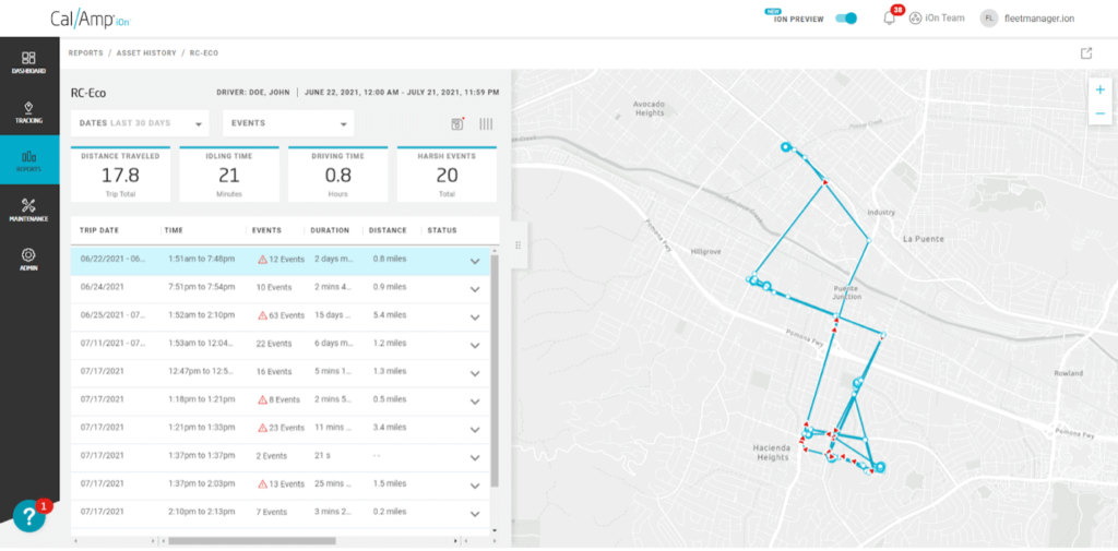
An Asset History report in CalAmp shows the breadcrumb activity trail for a particular vehicle over a specified period of time. (Credit: CalAmp).
Creating geofences around your routes, zones, parcels or other landmarks in your GIS lets you track all activity within those geofences. Configure alerts to be notified via phone, email or the notification screen in CalAmp's application when a vehicle exits the geofence. When using your GIS map layers in CalAmp's application, there’s no need to redraw the geofence when the landmark changes.
Want to see the real-world environment around a parcel, fire hydrant, stop sign or other landmark from your GIS in advance? Access the Google Maps Street View to glimpse in a pop-up window a recently captured image of the specific area.
Streamlining fleet operations
Geofencing the lot at headquarters can automate the check-in of maintenance vehicles before those vehicles hit the road.
Virginia Department of Transportation (VDOT) fleet supervisors used this approach to check in employee and contractor vehicles when snow plows and graders were called in before a storm. The geofences enabled administrators to not only check in vehicles remotely but also digitally log work hours for more accurate payroll processing.
Enabling public facing web portals
iOn can pump automatic vehicle location (AVL) data into applications you build using your proprietary ArcGIS map data. For example, say you want to build a public facing snowplow map that allows residents to see the real-time location of all snow plows in their area. CalAmp can provide the AVL data to make it happen.
VDOT launched such a portal in 2018. During or after a snowstorm, residents can type in their address to see whether a plow has been assigned to their area and even track its progress.
Similar websites can be created to show the location of solid waste trucks, recycling trucks, street sweepers or mosquito sprayers so homeowners know where they are without needing to call your office.
Integrating real-time AVL data from CalAmp's application is as simple as clicking “add layer” and plugging in a URL. Voila, your vehicles will show up on the map you’re building.
Telematics-based fleet management software and Esri ArcGIS mapping tools each bring substantial value on their own. Merging them provides government agencies, municipalities and large companies the ability to better leverage mobile assets, enhance public information services, cut costs and improve productivity in a mission-driven environment.
CalAmp is a Silver Esri Partner. To learn more about how CalAmp can help you improve operations, fleet management and dispatching in your organization, contact us today or schedule a free demo.